


WinGPS™ Marine

คำอธิบายของWinGPS™ Marine
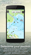
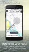
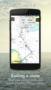
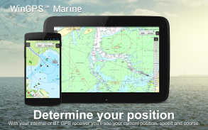
WinGPS Marine นำเสนอเครื่องมือนำทางที่ทันสมัยและง่ายต่อการเรียนรู้สำหรับการเดินทางที่ปลอดภัย กดแผนภูมิค้างไว้เพื่อวางแผนเส้นทางของคุณ GPS บนเครื่องจะแสดงตำแหน่งที่แน่นอนของคุณ ดาวน์โหลดแผนภูมิลงในอุปกรณ์ของคุณและล่องเรือแบบออฟไลน์ด้วยแผนภูมิที่อัปเดตล่าสุด เชื่อมต่อ AIS ของคุณผ่าน WIFI และป้องกันการชนที่อาจเกิดขึ้น
พัฒนาโดย Stentec สำหรับการนำทางบนเรือใบและเรือยอชท์ เรือสลุบและเรือแคนูในทะเล น้ำขึ้นน้ำลงและบนบก เหมาะอย่างยิ่งสำหรับการเช่าหรือเช่าเหมาลำเรือ
• การสนับสนุนทางน้ำสำหรับแผนภูมิภายในประเทศยุโรปตะวันตกและ Donau พร้อมข้อมูลสะพาน ล็อค และข้อมูลทางน้ำ ด้วยสิ่งนี้ คุณสามารถวางแผนและปรับเส้นทางของคุณได้อย่างรวดเร็ว โดยระบุสิ่งกีดขวางต่างๆ ชื่อของทางน้ำและระยะทางจะแสดงในระหว่างการเดินทางของคุณ
• การติดฉลากอัจฉริยะช่วยป้องกันป้ายข้อความที่ทับซ้อนกัน (รวมถึงทางน้ำด้วย) เพื่อให้ได้ภาพแผนภูมิที่เหมาะสมที่สุด ข้อมูลบริดจ์และล็อคจะสามารถอ่านได้เสมอบนแผนภูมิการหมุนเวียนของ Course Up
ไฮไลท์
•การนำทางบนแผนภูมิที่ทันสมัยของ Stentec, Imray, NOAA และ Delius Klasing
• รองรับการ์ด SD สำหรับการจัดเก็บแผนภูมิ
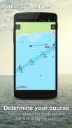
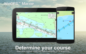
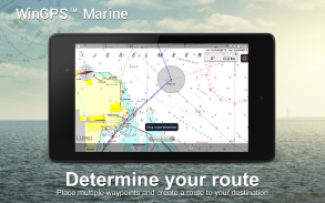
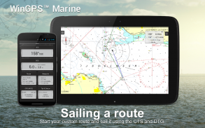
• จัดการเส้นทาง แผนภูมิ เส้นทาง และจุดอ้างอิง
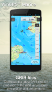
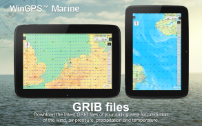
• ไฟล์ NOAA World GRIB: ลม ความกดอากาศ ปริมาณน้ำฝน และอุณหภูมิ
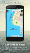
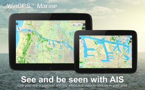
• เชื่อมต่อ AIS และ GPS ผ่านการเชื่อมต่อ WIFI ไร้สายหรือ Bluetooth
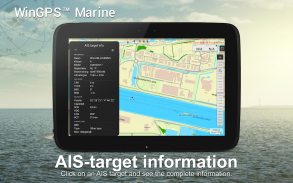
• ป้องกันการชนกับเวกเตอร์ความเร็วของเรือ AIS
• ปุ่ม Man-overboard ช่วยดึงลูกเรือที่สูญหาย
• แผนภูมิเคลื่อนที่ไปตามตำแหน่ง GPS ตรงกลาง NorthUp, CourseUp (มารีน) หรือ HeadUp (บวก)
• Harmoniemodel KNMI พร้อมการพยากรณ์อากาศโดยละเอียด (รวมถึงเนเธอร์แลนด์เท่านั้น)
• การทำนายคลื่น NOAA ในทะเลเปิด (บวก, ทั่วโลก)
เมื่อติดตั้ง WinGPS Marine เป็นครั้งแรก นี่จะเป็น WinGPS Marine Lite ที่มีฟังก์ชันจำกัด เหมาะอย่างยิ่งสำหรับโปรแกรมดูแผนภูมิพร้อมรองรับ GPS
การซื้อในแอป
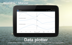
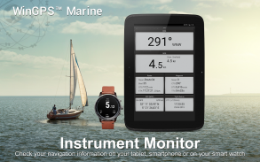
หลังจากติดตั้ง WinGPS Marine คุณจะปลดล็อคความสามารถเต็มรูปแบบของระบบนำทางส่วนบุคคลของคุณ ตอนนี้คุณสามารถวางแผนเส้นทาง ดาวน์โหลดไฟล์ GRIB บันทึกเส้นทางก่อนหน้า และเชื่อมต่อ AIS และ GPS ได้แล้ว ใช้ตารางเวลาที่สะดวกเพื่อดูลม ฝน ความกดอากาศ และเป้าหมาย AIS
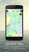
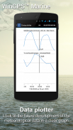
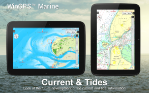
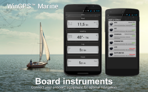
ด้วยการอัพเกรด WinGPS Marine Plus คุณจะสามารถเชื่อมต่ออุปกรณ์บอร์ดเพิ่มเติมผ่านการเชื่อมต่อไร้สายกับบอร์ดพีซี มัลติเพล็กเซอร์ หรือทรานสปอนเดอร์ AIS คุณสามารถแสดงข้อมูลปัจจุบันและข้อมูลน้ำขึ้นน้ำลงในตัวพล็อตเตอร์ข้อมูลของคุณ หรือดูข้อมูลดังกล่าวบนแผนภูมิได้ นอกจากนี้ยังรองรับแบบจำลองสภาพอากาศ Harmonie ขั้นสูงของ KNMI เช่นเดียวกับคลื่น NOAA ทั่วโลก
KUSTFIJN Getijmodel Rijkswaterstaat ที่มีลมสองวันขึ้นอยู่กับการคาดการณ์กระแสน้ำ กระแสน้ำ และระดับน้ำบน Waddenzee, Ijsselmeer, Markermeer, Randmeren และ Zeeland เส้นความลึกสีแดงจะจำกัดเส้นทางน้ำที่ปลอดภัย ขึ้นอยู่กับความลึก กระแสน้ำ และการเบี่ยงเบนเนื่องจากลม
ความครอบคลุมของแผนภูมิและการติดตั้งแผนภูมิ
เมื่อคุณเริ่ม WinGPS Marine คุณจะเห็นแผนภูมิเริ่มต้นภูมิประเทศ (ออนไลน์) ของ ESRI โดยอัตโนมัติ คุณยังสามารถเปิดแผนภูมิ NOAA ของสหรัฐอเมริกาและดาวน์โหลดแผนภูมิโลกฟรีผ่านทาง Chart Manager
เพื่อการนำทางที่ปลอดภัย คุณสามารถซื้อแผนภูมิดิจิทัลได้ที่ www.stentec.com นอกจากนี้ยังสามารถซื้อแผนภูมิในแอปหรือผ่าน Google Play™ ได้อีกด้วย แผนภูมิของคุณสามารถติดตั้งได้บนอุปกรณ์ที่แตกต่างกัน 3 เครื่อง ตัวอย่างเช่น บนแท็บเล็ต Android โทรศัพท์ และแล็ปท็อปหรือคอมพิวเตอร์ Windows
เข้าสู่ระบบด้วยบัญชี Stentec ของคุณในแอป Marine และดาวน์โหลดหรืออัปเดตแผนภูมิ DKW2 ที่ซื้อมาในตัวจัดการแผนภูมิ
ตัวอย่างเช่น ซีรีส์ DKW1800 ยอดนิยมพร้อมการอัปเดต BaZ รายสัปดาห์ และแผนภูมิ NL พร้อมการอัปเดตรายปักษ์ ร้านค้าออนไลน์ของเรานำเสนอแผนภูมิทะเลที่ทันสมัยและแผนภูมิภายในประเทศทั้งหมดของยุโรปตะวันตก รวมถึง Donau
ข้อมูลมากกว่านี้:
www.wingpsmarine.com
นโยบายความเป็นส่วนตัว:
www.stentec.com/en/en/privacy-statement
ข้อมูลผู้ใช้
สำหรับการปรับปรุงแอป เราสนใจประสบการณ์และข้อเสนอแนะของคุณเป็นอย่างมาก กรุณาส่งอีเมลไปที่ helpdesk@stentec.com
WinGPS™ Marine--เวอร์ชั่น4.76
(23-04-2025)
WinGPS™ Marine - ข้อมูล APK
เวอร์ชั่น APK: 4.76แพ็คเกจ: com.stentec.wingps_marine_liteเวอร์ชั่นล่าสุดของWinGPS™ Marine
เวอร์ชั่นอื่น


แอปในประเภทเดียวกัน


คุณอาจจะชอบ...


